Do you want to know more about key innovations and solutions related to immunization taking place within the DHIS2 community?
English-language webinar on 17 December, 14:00 - 15:30 Oslo time (GMT+1)
Join the DHIS2 team for the last quarterly webinar of the year included in our DHIS2 for immunization series! This webinar is organized by HISP UiO with support from Gavi.
The University of Oslo is excited to announce the upcoming DHIS2 Immunization webinar focusing on micro-planning solutions and innovations that will take place on Friday 17 December at 14:00 Oslo time (GMT+1).
For this last webinar of the year, we are pleased to announce that we will be joined by experts from the MAHA organization, Grid3, and Flowminder (TBC) to share their implementation insights on micro-planning tools, population mobility mapping, EPI catch-up application, risk analysis, settlement extraction, and high-res population estimates.
The webinar will feature the following presentations:
The MAHA organization will be presenting innovative micro-planning-GIS solutions through:
1- Static and smart map platform to optimize efficiency in field activities through micro-planning tools.
2- EPI Monitoring & catch-up app to allow identification of bottlenecks across health programs.
3- Geospatial Platform to better prioritize your activities and coordinate all the stakeholders
GRID3 (Geo-Referenced Infrastructure and Demographic Data for Development) will be presenting details around the use of geospatial data solutions for immunization Interventions.
Flowminder - content TBC
This webinar will take place on Friday 17 December, 14:00-15:30 Oslo time. You can register for this free event through our online form and you will receive a link to the webinar before the event takes place.
This sounds fascinating …
I have been working in Zambia on microplanning using RED guidelines and GRID3 maps … unfortunately the current practice (from the RED microplanning guidelines) is to
collect this microplanning data in Excel and NOT to use DHIS2.
Collect supervision data on paper
Do Monitoring in DHIS2 (though not specified which indicators to use)
My questions are
Why is there no guidance in the WHO Afro/ UNICEF microplanning guidelines to use DHIS2? (or the national HIS)
How can we reduce the amunt of data collected to make it more relevant
How to convince districts to follow up on the micro-plans … they are made once a year to get money, then never looked at again
To all the participants of the webinar,
My name is Raphael Girod and I am the founder of the MAHA organization, which stands for Mapping & Analytics for Health Activities. It is a great pleasure to introduce our Microplanning-GIS applications/solutions, thanks to our talented GIS experts and developpers.
Prior to the presentation, I am pleased to forward you the url links to the One pager Technical briefs, and more interestingly, to the on-line DEMO apps (see hyperlink below).
I am looking forward to talking with you so to contribute to your challenges.
With kind regards
Raphael
@Carine …working at the district in Zambia I am bound by RED guidelines which propose TOO MUCH data … over 1,000 data elements that are collected on Excel … once a year … and then is never looked at …
Does GAVI have any morte realistic microplanning guidelines for us to use at local level
Hi Silvia
Thank you very much for a great presentation… Can you please explain, you said maps are already available with you for various countries. SO for example if we would like to begin GIS Microplanning in Malawi, what would be the requirements from country and what information you will be already having with you.
Thanks
Arthur, very interesting point regarding the lack of utilization/follow up of microplans. it goes to show how a huge component of strengthening the use of GIS for microplanning is more about focusing on people and processes and the ability to absorb the technology at the front line level,
Did you carry out any initial assessment to find out what similar tools exists and/or already embedded into DHIS2?
What is the frequency of updating the Geospatial-extent to ensure recent changes due to natural / human disasters are captured? Overall, Thank you for this innovation.
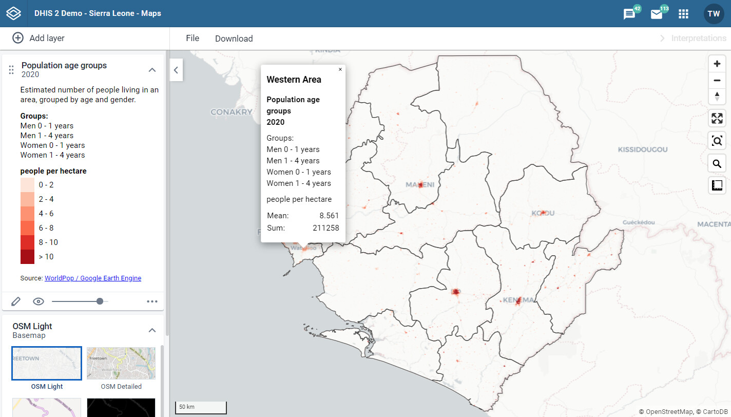
Having these detailed population data available in the DHIS2 Maps module available for manual interactive (map-based) analysis is great and definitely a major improvement. Are there plans 1) to enable more automated spatial analysis using population data, and/or 2) to make the population data available across analytics, so that these can be used e.g. as denominators in coverage indicators?
@sylvia and team
Great presentation … really interesting to see what you are doing apart from your fantastic work with us in Chinsali
Interested in the CHA mapping … would like to duplicate in Chinsali and indeed all Muchinga
Hi Lokesh, thanks for your question. Let’s set up a call and discuss this further. We have settlement extents and WorldPop data available for Malawi and I think you have an open health facility dataset right? We would not need too much more… Please pop me an email at silvia.renn@gmail.com
Hi Williams, thanks for your question. We always check what systems are available. We just create data though not systems. If the government wants to update data we can work with the government to do so. There may be many different ways to do so, including through machine learning or by leveraging i.e. existing field work or data coming in through existing systems.
To all the participants of the webinar,
My name is Yingtao and I am a lead technical analyst at Fraym. We have been in collaboration with GRID3 since 2020, and we map demographic, socioeconomic, behavioral, and attitudinal information at a granular level across geographies to inform planning and decision making. Feel free to visit our website and request a demo/report for more information: Resources - Fraym.
Hi Lora, in Zambia this was used to help assess the need for more CHWs which was then used for budgeting. In Ethiopia the maps were used by Amref and MoH partners to prioritize the location of mobile health units in areas with largely pastoral communities.