Dear Community of Practice and Climate Enthusiasts,
We have recently developed a pilot DHIS2 Climate Data App!
This pilot app is intended to help you identify causal relationships between climate factors and health outcomes, which can then be used to design early warning systems for a variety of health use cases, by providing a means to easily import and explore historical and current weather data in DHIS2.
This app is part of the ongoing “DHIS2 for Climate“ project: Climate - DHIS2. It will get frequent updates, so please make sure you have the latest version from the DHIS2 App Hub. The app is developed by the University of Oslo, but it is not a DHIS2 core app. Useful parts of this app might be incorporated into the DHIS2 core in the future, based on your feedback.
Please read the announcement below for more information and instructions on installing and using the app, and let us know if you have questions or comments at climate-app@dhis2.org.
We also invite you to join a webinar on 23 April at 12:00 GMT to learn more about the pilot DHIS2 Climate Data App, including a demo and insights from use cases. You can register for the webinar through this link: https://us06web.zoom.us/meeting/register/tZUvf-mrqTstGNDu6dulpm46_nABnwx44Y6f#/registration
Warmly,
C&H Team
Announcing the DHIS2 Climate Data App
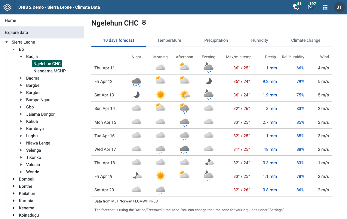
The DHIS2 Climate Data app allows you to explore daily and monthly temperature, precipitation, and humidity data for your organization units, and to import weather and climate data into DHIS2 data elements. The app is now available on DHIS2 App Hub.
The data source is ERA5-Land, considered the most accurate and complete climate dataset available with worldwide coverage. This video shows you how this dataset was created by combining weather observations with a weather model to fill the missing gaps (climate reanalysis).
The data is calculated for your organization units on Google Earth Engine, and you need to have the Earth Engine enabled for your DHIS2 instance to use this app.
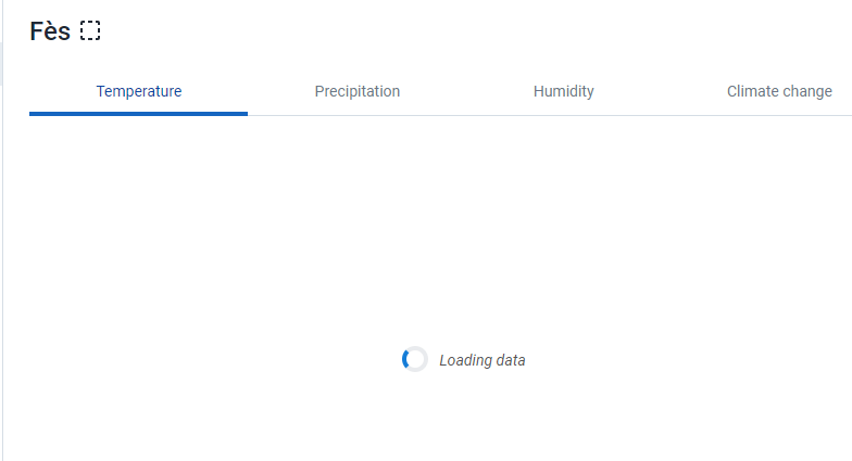
Explore temperature, precipitation and humidity data
Temperature, precipitation, and humidity data can be explored for your organization units directly in the app. When you select an organization unit the following charts will be available:
- Average temperature and the temperature range (monthly and daily).
- Precipitation (monthly and daily). Monthly values can be compared with averages from a 30-year reference period (1991-2020 and 1961-1990).
- Humidity (monthly and daily), showing relative humidity combined with air temperature and dewpoint temperature.
- Temperature anomaly, which shows how the monthly average temperature has changed since 1970.

The period can be adjusted for all the chart types.
Import weather and climate data
Temperature, precipitation, and humidity data can easily be imported into DHIS2 data elements through this app. This will allow you to combine weather and climate data with your health data across all DHIS2 analytics apps. The app includes a setup guide for how to configure the data elements.
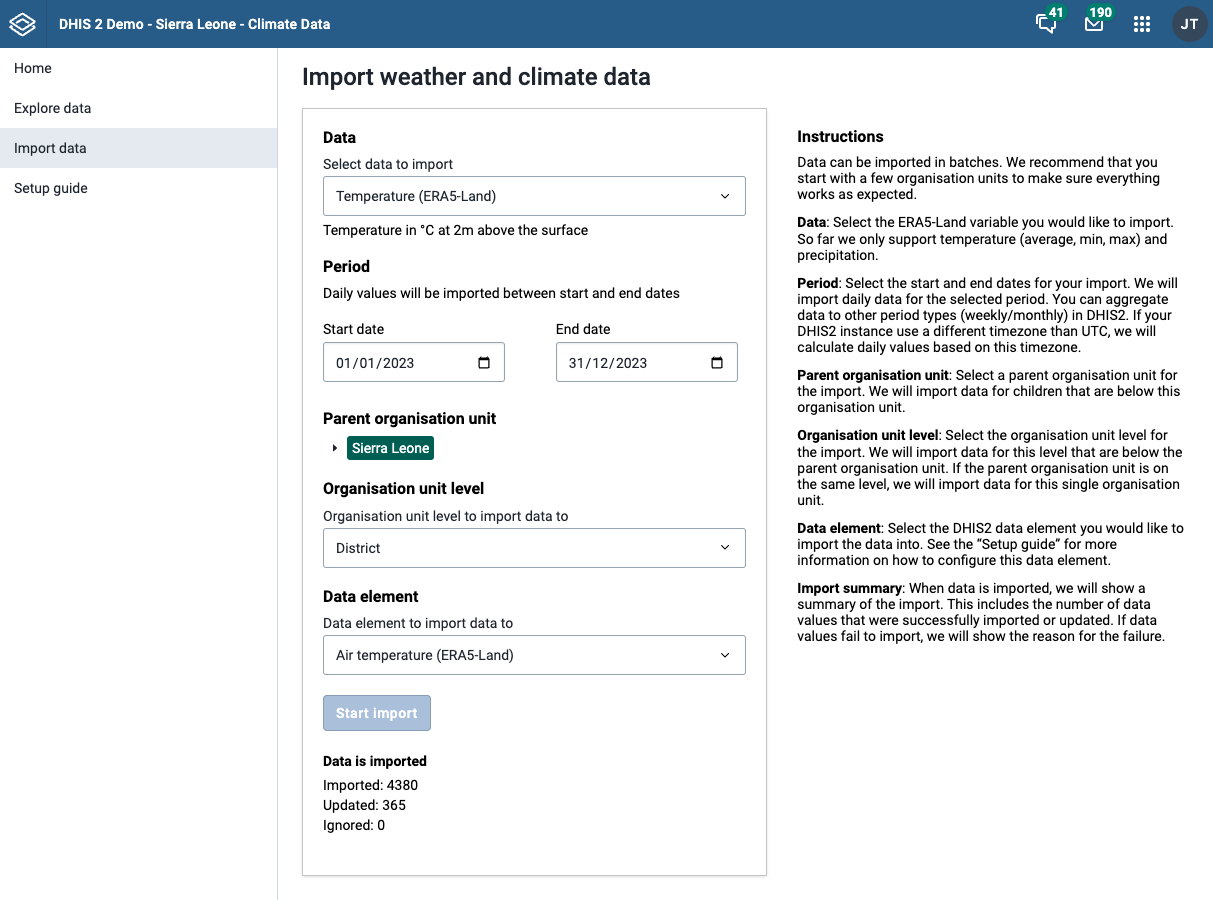
We import daily temperature, precipitation, and humidity values, that will allow you to aggregate data into other period types (e.g. weekly or monthly) in DHIS2. In this way, you can easily match the periodicity of your health data.
Using weather and climate data in DHIS2
In many health programs–such as infectious disease surveillance, maternal and child health, and nutrition and food security–health outcomes can be directly and indirectly influenced by local climate variation, extreme weather events, and changes in human behavior linked to weather factors and climate change. Understanding the relationship between climate data and health outcomes is essential for developing effective public health interventions and adaptation strategies.
For instance, malaria research often emphasizes the relationship between temperature and the spread of the disease. Climate data, such as temperature, rainfall and humidity, and vector presence or density could be useful to predict outbreaks and minimize their health effects. Such data integration could help infectious disease programs understand where vector populations may be changing, which geographies and populations may be at the highest risk for increased transmission, the length of seasonal periods of high transmission, and which catchment areas may need to prepare for future health demands.
Warmer temperatures, altered precipitation patterns, and extreme weather events, such as droughts, floods, and storms, pose immediate threats to food production and supply chains. These events can damage or alter the geographical distribution and cultivation conditions of crops, disrupt transportation networks, compromise access to food, and ultimately influence dietary patterns and nutritional outcomes, particularly in vulnerable communities. Combining climate data with routine health data on human malnutrition can show the impact of agricultural adaptation measures on human health, and assist in planning nutrition interventions of extreme weather events.
Extreme weather events, intensified by climate change, pose immediate risks to human health through injuries, displacement, and mental health issues, and changes in temperature, humidity, air quality, and the frequency of extreme weather events all have implications for respiratory health such as asthma and chronic obstructive pulmonary disease (COPD). Moreover, climate change exacerbates existing health disparities, disproportionately affecting vulnerable populations such as the elderly, children, and low-income communities. These groups often have limited access to healthcare and resources to adapt to changing environmental conditions. Incorporating climate data into health surveillance systems can help identify vulnerable populations and anticipate changes in disease burden associated with climate variability and change.
Recognising the interconnected nature of climate change and health, it is crucial to adopt an effective approach to address these challenges. Climate and health data integration provides a holistic view of how climate factors contribute to health risks, enabling a deeper understanding of the relationship between environmental conditions associated with climate and disease occurrences.
You can find additional information on using DHIS2 for Climate & Health, plus links to external resources, on our website: Climate - DHIS2
Please provide your feedback
Please contact us at climate-app@dhis2.org if you have any difficulties using this app, or have suggestions for how we can improve it.
Useful feedback for us includes:
- Is the app working for your DHIS2 instance? What DHIS2 instance are you using?
- Are you able to see weather and climate charts for your org units under “Explore”?
- Try to use the setup guide to add one or more data elements for importing data. Is anything missing in the setup guide?
- Are you able to import temperature/precipitation/humidity data to your DHIS2 instance?
- Are you able to show temperature, precipitation and humidity data in the DHIS2 analytics apps? (remember to generate the analytics tables after doing an import)
- Are you able to combine weather and climate data with health data on your DHIS2 instance using the analytics apps? Do you see any patterns or linkages (these relationships are often complex)?