Hi Community
On DHIS2 Andoid: The map used by default for Morocco does not integrate the Moroccan Sahara, and that poses a delicate political problem.
is it possible to change this map?
Thank You
Hi Community
On DHIS2 Andoid: The map used by default for Morocco does not integrate the Moroccan Sahara, and that poses a delicate political problem.
is it possible to change this map?
Thank You
Hi @elmoujarrade,
Thank you for your question! It’d be nice to see what’s the map you are using and where is it available? If you go to the Maps app and view all the basemaps available, do you still see the same thing? If Bing, OpenStreetMap…etc don’t show the map that you use then maybe exporting it to QGIS could be helpful.
Hi, @elmoujarrade . The Android App uses Mapbox (https://www.mapbox.com/) as the map source which considers Western Sahara as an entity. There is not much we can do regarding this. We understand this might present a political issue. Would you mind creating a JIRA Feature issue?
Western Sahara is internationally a seperate country and has nothing to do wih Morroco kingdom as Google maps states.
Please, no more political issues on dhis2 community! We are here to learn no matter where you are in the planet! No need to tackle with these political issues!
Thanks for your comprehension
This is an interesting discussion, and the DHIS2 team appreciates that map boundaries can be a very sensitive (and political) issue! Thanks, @Kgalil for the encouragement to set borders aside on the CoP, so that everyone can take part in and benefit from the global exchange of ideas here.
Within the core DHIS2 software, it is possible to configure your DHIS2 instance to use a basemap of your choice, so you can select one that reflects the boundaries that align with your government or organization’s position. Starting in version 2.38, we will also add support for vector style basemaps (this is a work in progress). @Bjorn_Sandvik can provide more details if anyone would like to learn more.
As @jaime.bosque noted, the Android App does not currently include this custom basemap functionality. Thanks @elmoujarrade for raising this issue. The team is looking into it!
Thank you for your reactions to this topic
We just want to use the great features that the DHIS2 Android app has to offer. for this we need to use a map which does not create internal discomfort. So I’m just raising a technical question (I don’t want to talk about the political issue) we just want to be free to choose the map that works for us,
if not, we will be unable to use DHIS2 Android and all that this fantastic app offers.
Please understand that
A JIRA ticket ([ANDROAPP-4457] - Jira) was created to consider the inclusion of a specific variable that could be defined a server level so the system administrators could define which map border definition to be used in the Android devices.
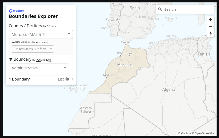
Currently Android uses Mapbox’s default tiles (US defined borders) and there is no the possibility of changing that. The US default map recognizes some areas as countries, in this case the Western Sahara as it can be seen here:
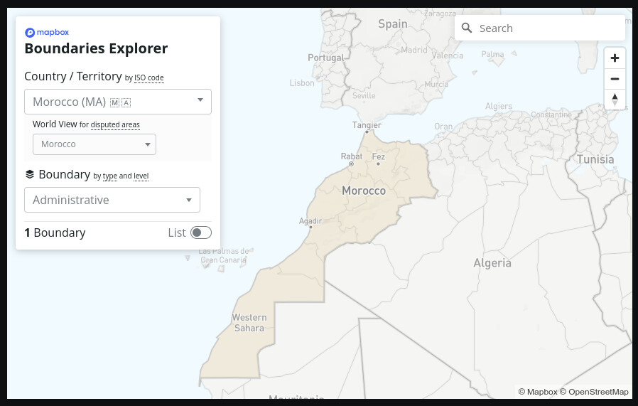
However, if this would be changed to Morocco, the border disappears:
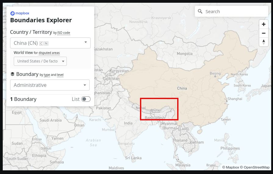
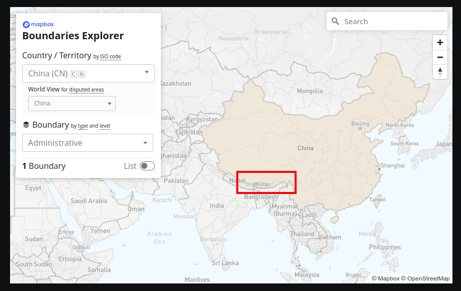
Same happens in other politically discussed areas, as the Southern Tibet:
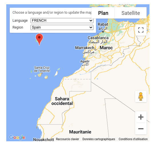
Some users might find this confusing as they are used to other Map applications (i.e. Google Maps) where while using specific locale settings the borders might be displayed as different. For example, a user opening Google Maps in Morocco would found that Morocco includes the Western Sahara:
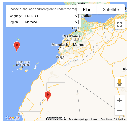
But not while opening the map from any other region of the world (Spain in this example):
Please, take this with a grain of salt as I don’t want to raise any political conflict and I am only talking from a technological perspective without taking any side in any possible discussion.
More information can be found here:
Thank you for following up on this and sharing all the valuable info @jaime.bosque! Looking forward to seeing this option available for android settings. ![]()
![]()
@jaime.bosque @Gassim
Thank you for these clarifications and we hope that this problem will be solved in the next version.